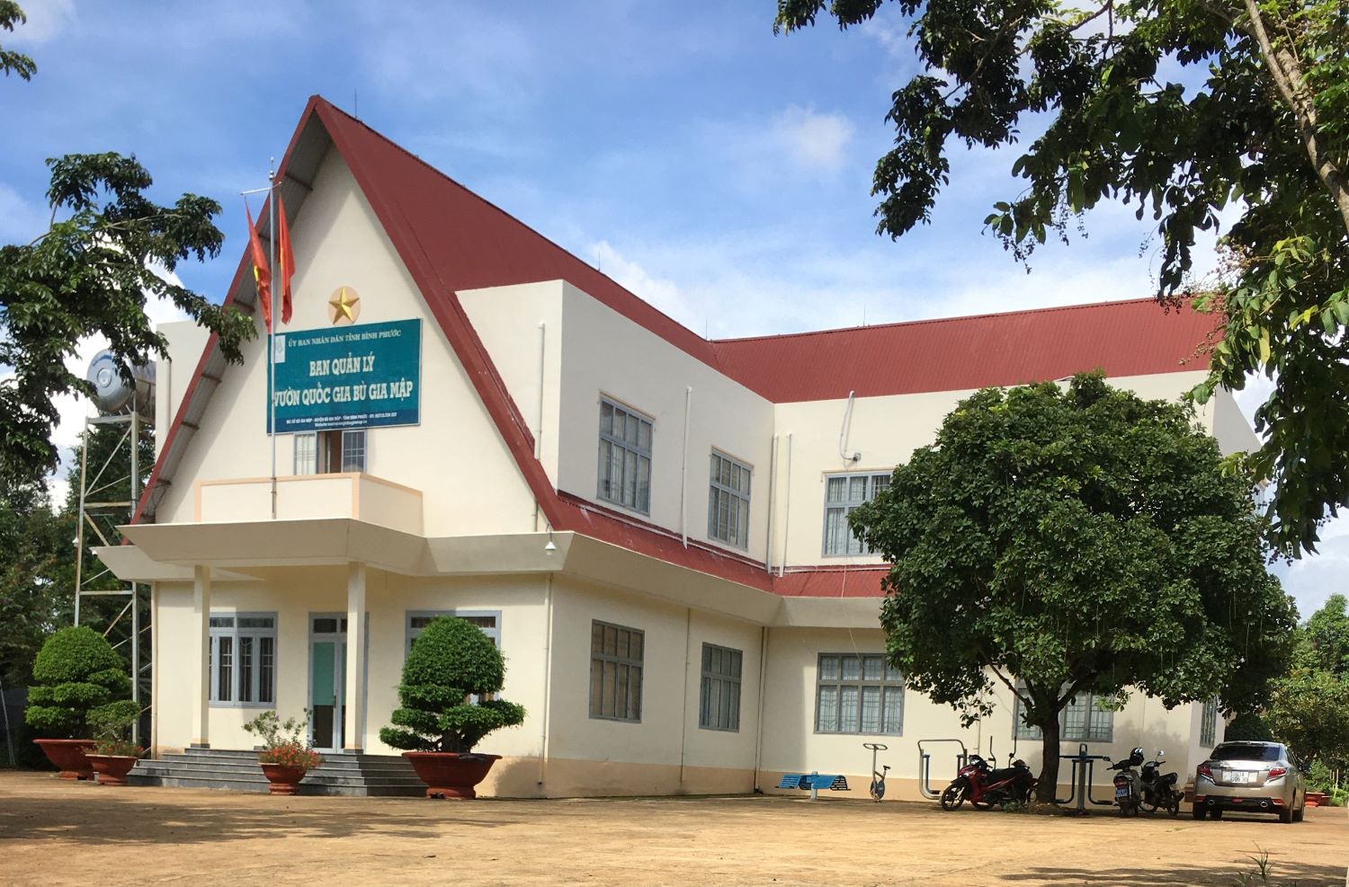
General introduction to the Bu Gia Map National Park
- TUEsday - 09/11/2021 14:46
- |Close page
Bu Gia Map National Park was upgraded from the Bu Gia Map Nature Reserve according to Decision No. 170/QĐ-TTg on 27 November 2002 to achieve the sustainable development goals of the region. Bu Gia Map National Park was created to conserve and develop typical evergreen ecosystems on lowland mountains below 1,000m, which characterize the features of transitional areas from the Central Highlands to the Southeast region of Vietnam. The total area of the Bu Gia Map National Park is 25.505 ha (4.134 ha of rich forests, 1.310 ha of average forests, 169 ha of poor forests, 304,8 ha of recovery forests, 17,851 ha of mixed forests, and 1,776.5 ha of bamboo forests). The Bu Gia Map National Park is a good place for scientific studies to conserve the genes sources of fauna and flora. With 90% of forest coverage, the Bu Gia Map National Park contributes to protecting the watershed of hydropower plants and reservoirs downstream of the Be River. With the values of landscapes and ecosystems, the Bu Gia Map National Park is one of the interesting ecotourism destinations because of natural forest ecosystems and mountain ranges from the plateau to the delta.
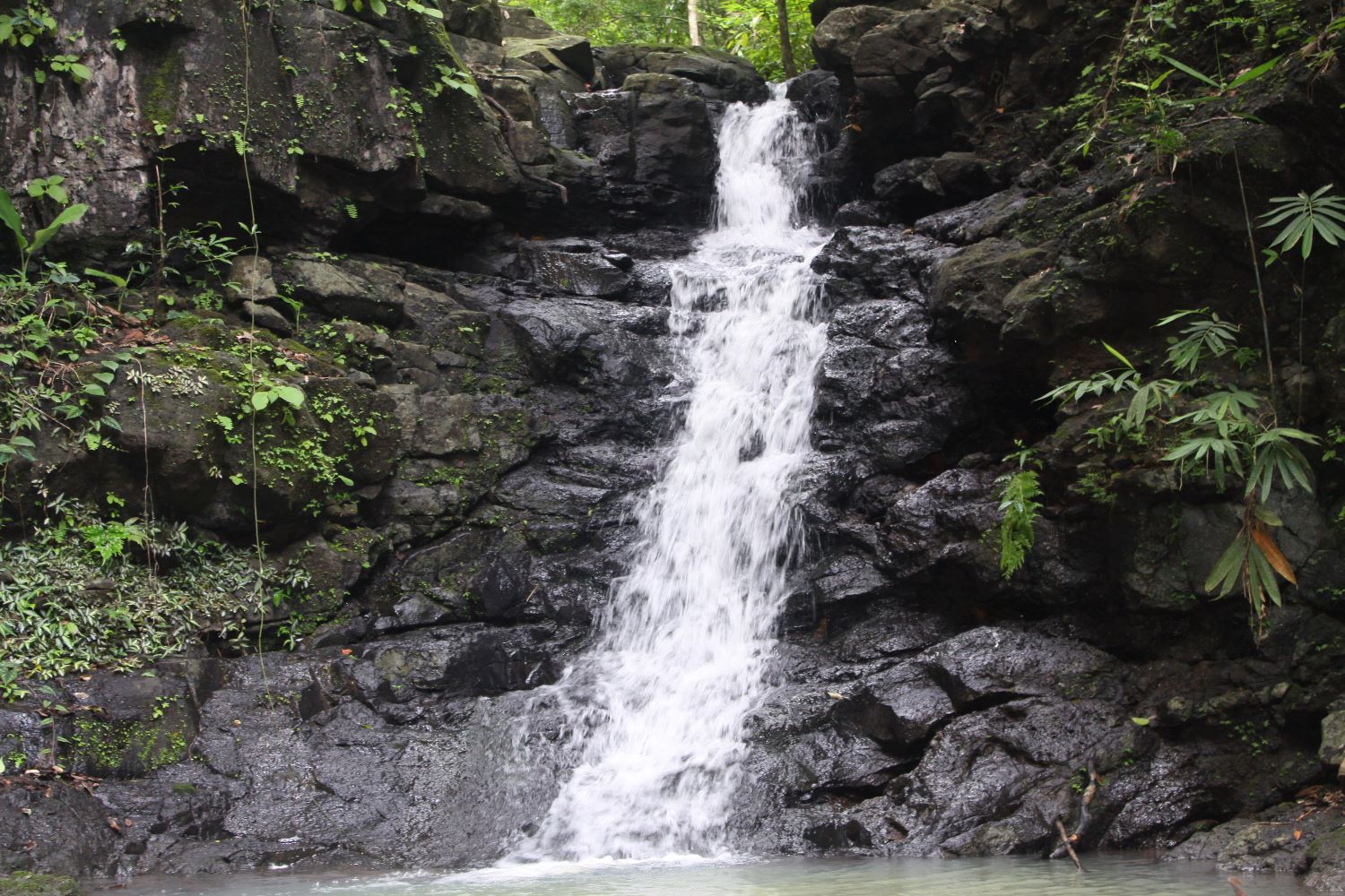
The Bu Gia Map National Park locates in a transitional area from the Central Highlands to the Southeast of Vietnam, so it has special characteristics regarding topography and streams. The topography of the Bu Gia Map National Park includes lowland mountains that reduce their height from the West to the East. The highest peak is 738 meters above sea level, and the highest mountains find nearby the Dak Nong Province. Because the park locates in a transitional area, its topography is strongly divided. Mountain ranges interlace with streams, which creates a diversity of landscapes and habitats for fauna and flora in the park. The highly divided topography also creates beautiful waterfalls that create beautiful sites for ecotourism activities within the park.

Natural forest habitat in the Bu Gia Map National Park
The Bu Gia Map National Park plays an important role in conserving the high values of biodiversity at both national and international levels. The Bu Gia Map National Park adjourns to other protected areas belonging to Cambodia and other protected areas in the East-West corridor that contributes to the conservation of yellow-cheeked crested gibbons, pangolins, Asian elephants, black-shanked douc langurs, and other globally threatened species. The Bu Gia Map National Park locates in a transitional area that characterizes the forest ecosystems on lowland at 300 – 750 meters above sea level. These features create a high diversity of habitats and species within the Bu Gia Map National Park.
A small stream inside the park
There are two typical forests within the Bu Gia Map National Park including evergreen and semi-evergreen tropical forests. These typical forests create a diversity of vegetables that supply natural habitats for many wild animals. Recent studies recorded 1,117 plant species belonging to 475 genera, 128 families, 59 orders, and five phyla including Lycopodiophyta, Equisetophyta, Polypodiophyta, Pinophyta, and Magnoliophyta. All genera have been updated following the latest names and removed all plantation species out of the list.
The Bu Gia Map National Park conserves many threatened species categorized by the IUCN and the Vietnamese government. Based on the IUCN red list and Decree No. 32/2006/NĐ-CP of the Vietnamese government, the Bu Gia Map National Park is one of the habitats of 52 plant species that need urgent conservation resolutions, amounting to
5,07% of the total number of species in the park. 18 species are at low risk, accounting for 1,75%. There are 15 vulnerable species (1,46%), 13 endangered species (1,27%) and 6 Critically Endangered (0,58%). Especially, the park still stores a large number of primary forests with a high volume of timber predominated by Dipterocarpaceae and Fabaceae such as Dalbergia Oliveri, afzelia xylocarp, Pterocarpus macrocarpus, and other threatened species. The high values of the biodiversity of vegetables create suitable habitats for many wild animals within the park.
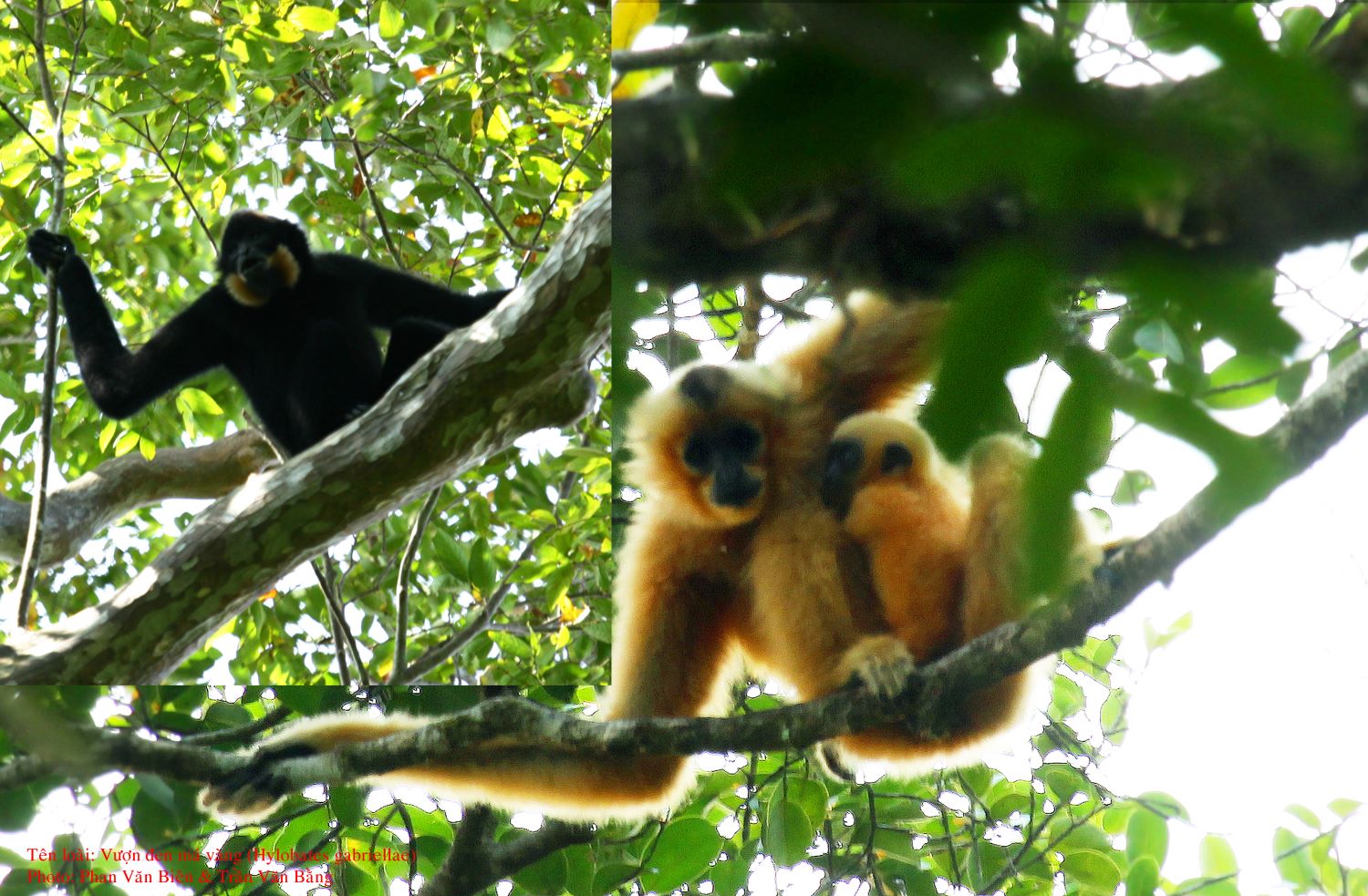
Yellow-sheeked crested gibbons in the Bu Gia Map National Park
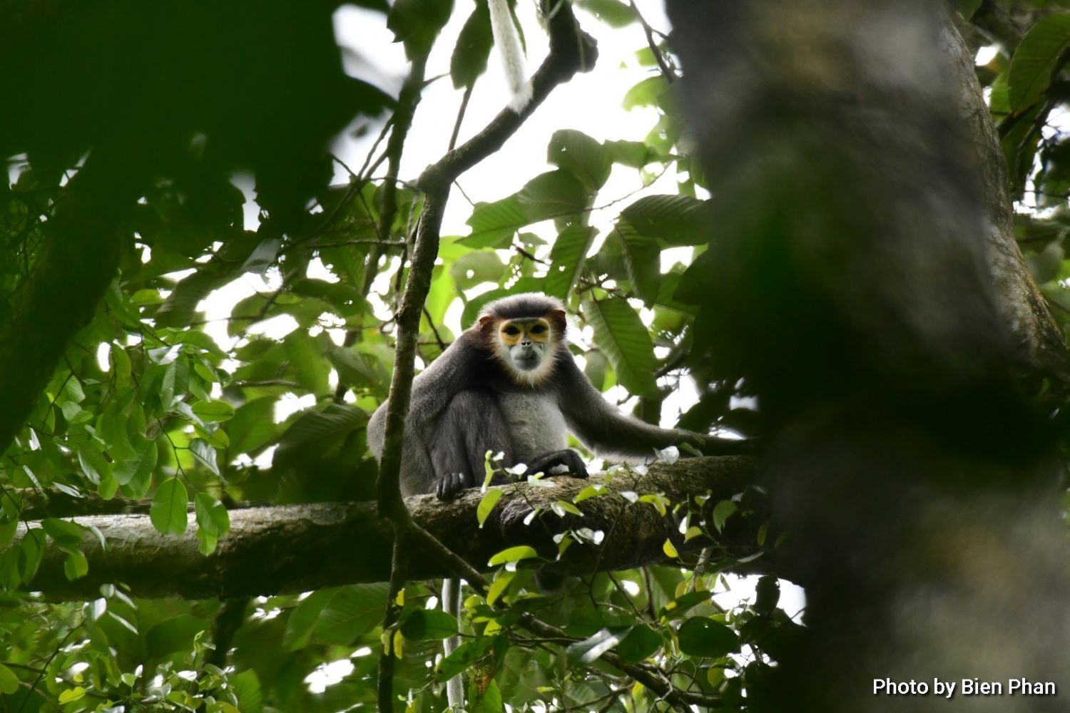
Black-shanked douc langur in the Bu Gia Map National Park 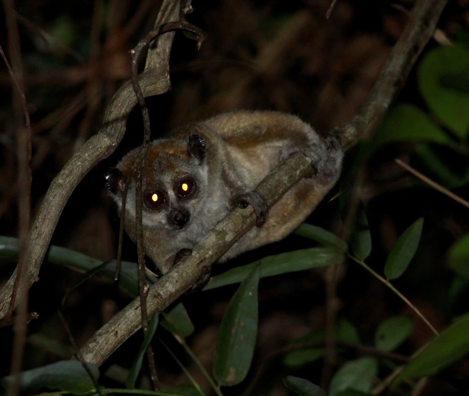
Slow loris in the Bu Gia Map National Park
There are two native ethnic minorities including S’Tieng and M’Nong, and they have close relationships with natural forests within the Bu Gia Map National Park. In the past, these groups lived on the edges of the Bu Gia Map National Park and relied on this resource to gather forest products and conduct a slash-and-burn system. The native groups have their tradition related to mountains and natural forests such as organizing gongs festivals, camping beside streams, creating sacred forests, playing leave air horns, organizing other cultural activities. Currently, the support from the government has reduced the reliance of these groups on natural forests and they have applied their indigenous knowledge to contribute to conserving natural forests in the Bu Gia Map National Park. Local people participate in the forest protection program under the Payment for Environmental Services and develop ecotourism to conserve biodiversity within the park.

Gong festival in the buffer zones of the Bu Gia Map National Park 
Historical vestige in the Bu Gia Map National Park
With natural and social characteristics, the Bu Gia Map National Park has been well-performing its mission in conserving biodiversity and conducting scientific studies to protect the watershed forest, ecotourism development, and economic development. To contemplate the beauty of the Bu Gia Map National Park, we can participate in activities to explore cultural features, travel along with the DT 741, go camping, visit sacred forests, visit the Center for Wildlife Rehabilitation and Organism Development, and try traditional food. These activities will enable us to have an overview of the coexistence in harmony between people and nature in the Bu Gia Map National Park.
The Bu Gia Map National Park locates in a transitional area from the Central Highlands to the Southeast of Vietnam, so it has special characteristics regarding topography and streams. The topography of the Bu Gia Map National Park includes lowland mountains that reduce their height from the West to the East. The highest peak is 738 meters above sea level, and the highest mountains find nearby the Dak Nong Province. Because the park locates in a transitional area, its topography is strongly divided. Mountain ranges interlace with streams, which creates a diversity of landscapes and habitats for fauna and flora in the park. The highly divided topography also creates beautiful waterfalls that create beautiful sites for ecotourism activities within the park.
Natural forest habitat in the Bu Gia Map National Park
The Bu Gia Map National Park plays an important role in conserving the high values of biodiversity at both national and international levels. The Bu Gia Map National Park adjourns to other protected areas belonging to Cambodia and other protected areas in the East-West corridor that contributes to the conservation of yellow-cheeked crested gibbons, pangolins, Asian elephants, black-shanked douc langurs, and other globally threatened species. The Bu Gia Map National Park locates in a transitional area that characterizes the forest ecosystems on lowland at 300 – 750 meters above sea level. These features create a high diversity of habitats and species within the Bu Gia Map National Park.
A small stream inside the park
There are two typical forests within the Bu Gia Map National Park including evergreen and semi-evergreen tropical forests. These typical forests create a diversity of vegetables that supply natural habitats for many wild animals. Recent studies recorded 1,117 plant species belonging to 475 genera, 128 families, 59 orders, and five phyla including Lycopodiophyta, Equisetophyta, Polypodiophyta, Pinophyta, and Magnoliophyta. All genera have been updated following the latest names and removed all plantation species out of the list.
The Bu Gia Map National Park conserves many threatened species categorized by the IUCN and the Vietnamese government. Based on the IUCN red list and Decree No. 32/2006/NĐ-CP of the Vietnamese government, the Bu Gia Map National Park is one of the habitats of 52 plant species that need urgent conservation resolutions, amounting to
5,07% of the total number of species in the park. 18 species are at low risk, accounting for 1,75%. There are 15 vulnerable species (1,46%), 13 endangered species (1,27%) and 6 Critically Endangered (0,58%). Especially, the park still stores a large number of primary forests with a high volume of timber predominated by Dipterocarpaceae and Fabaceae such as Dalbergia Oliveri, afzelia xylocarp, Pterocarpus macrocarpus, and other threatened species. The high values of the biodiversity of vegetables create suitable habitats for many wild animals within the park.
Yellow-sheeked crested gibbons in the Bu Gia Map National Park
The diversity of vegetables creates suitable habitats for wild animals, meaning that the Bu Gia Map National Park is the refuge of a high diversity of wild animals. Scientists have recorded 104 mammals belonging to 70 genus, 29 families, and 12 orders. They also listed 246 bird species belonging to 45 families and 15 orders. In addition, scientists recorded 63 amphibians and reptiles belonging to 19 families, three orders, and two classes. Scientists also listed 39 freshwater fish in the streams of the Bu Gia Map National Park. Surveys also indicated that there are 273 insect species within the Bu Gia Map National Park. The high values of diversity contribute to creating a good environment for local communities regarding their culture, economy, and society.
Black-shanked douc langur in the Bu Gia Map National Park
Slow loris in the Bu Gia Map National Park
There are two native ethnic minorities including S’Tieng and M’Nong, and they have close relationships with natural forests within the Bu Gia Map National Park. In the past, these groups lived on the edges of the Bu Gia Map National Park and relied on this resource to gather forest products and conduct a slash-and-burn system. The native groups have their tradition related to mountains and natural forests such as organizing gongs festivals, camping beside streams, creating sacred forests, playing leave air horns, organizing other cultural activities. Currently, the support from the government has reduced the reliance of these groups on natural forests and they have applied their indigenous knowledge to contribute to conserving natural forests in the Bu Gia Map National Park. Local people participate in the forest protection program under the Payment for Environmental Services and develop ecotourism to conserve biodiversity within the park.
Gong festival in the buffer zones of the Bu Gia Map National Park
Local communities have been exploited their internal assets to develop eco-tourism activities within the Bu Gia Map National Park and surrounding vicinities. These communities still preserve cultural features that may enable them to serve tourists such as holding gongs festivals, playing leaf air horns, protecting sacred forests, making traditional textures, and creating handicrafts. They also make traditional food dishes that stand for their cultures such as straw liquor, soup in bamboo tubes, mixed soup, rice in bamboo tubes, and other special food dishes. These activities combined with the natural conditions of the Bu Gia Map National Park and historical vestiges create a cultural space in the Bu Gia Map National Park.
The Bu Gia Map National Park stores many historic vestiges representing the history of the country. The road DT741 through the Bu Gia Map National Park is the main route linking the Central Highlands to the Southeast of Vietnam. Although this road was designed on a complex territory that is divided by streams and mountains, there is not any bridge crossing streams and rivers, but it still ensures the technical and economic parameters of the design. Along the DT741, we can contemplate vestiges of the end pipe of the last petrol station that served the Vietnamese military in the American war. We also have opportunities to observe the Hoang Cam stove, a stoved named after a soldier who invented it, it was commonly used in the two wars of the Vietnamese people.
Historical vestige in the Bu Gia Map National Park
With natural and social characteristics, the Bu Gia Map National Park has been well-performing its mission in conserving biodiversity and conducting scientific studies to protect the watershed forest, ecotourism development, and economic development. To contemplate the beauty of the Bu Gia Map National Park, we can participate in activities to explore cultural features, travel along with the DT 741, go camping, visit sacred forests, visit the Center for Wildlife Rehabilitation and Organism Development, and try traditional food. These activities will enable us to have an overview of the coexistence in harmony between people and nature in the Bu Gia Map National Park.